Demographic Retrieval Methodology
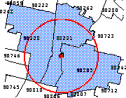
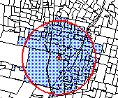
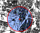
The Demographic Analysis tools in Alteryx use the Allocate Engine to retrieve demographic data. Allocate utilizes a unique and more accurate approach to allocating demographic data to irregular polygons such as circles, travel contours, and custom trade areas. The approach results in a more accurate apportioning of block group-level databases to these non-standard areas. Stored within the Allocate engine are over 5 million block centroids covering every Census-defined block in the United States. Along with each block centroid's latitude and longitude coordinates, is stored the corresponding population and household count for that particular block. When an irregular polygon gets passed to the Allocate engine, Allocate first identifies which block centroids are contained within it. Block centroids found inside the polygon are associated with other block centroids having the same block group code. The population and household counts of the blocks are aggregated, expressed as a percentage of the corresponding block group's total population and household count, and then applied to each of the block group attributes being requested for an Allocate database or report.
Block centroid retrieval is considerably more accurate than all other available techniques because it leverages known information about the relationship to blocks and block groups to any custom trade area while eliminating unknown information that other techniques assume to be true about these relationships. Geographic Information Systems commonly offer users several logical options for allocating data to a custom polygon, none of which are very accurate or as true as block centroid retrieval. These techniques include area weighting, polygon touching, polygon contained within, and point in polygon.
Area Weighting
Area weighting calculates the land area contained inside the polygon and then applies the percentage of land area to the source data to generate the necessary demographic information. This approach assumes a one-to-one relationship between land area and population and households. Only block centroid allocation can detect open spaces like parks, schools, and public areas such as commercial centers, malls, and office complexes, all of which impact the correct amount of data to be assigned to your trade area.
To compensate for this known error in assumptions, GIS providers allow users to:
Allocate all of the data to a polygon if the trade area touches the source area or its geographic centroid.
Allocate none of the data to a polygon if the trade area does not fully encapsulate the source area or its geographic centroid.
These techniques are only adequate if the trade area is large relative to the size of the source area the desired data is stored at (for example, 5 miles with block groups, 10 miles with census tracts, and 20 miles with zip codes).
Allocate provides block centroid retrieval regardless of the size or shape of your custom polygon or the level of geography you license for use with your GIS. The examples below demonstrate the accuracy of other techniques as compared to Allocate's.
ZIP Code Centroids

Miles | Households | % Error |
|---|---|---|
1 | 11,104 | +134% |
2 | 48,995 | +95% |
3 | 119,706 | +118% |
Block Group Centroids

Miles | Households | % Error |
|---|---|---|
1 | 5,065 | +134% |
2 | 28,031 | +95% |
3 | 68,321 | +118% |
Allocate Block Centroids

Miles | Households | % Error |
|---|---|---|
1 | 4,748 | N/A |
2 | 25,169 | N/A |
3 | 54,896 | N/A |
